On May 17, 2017, Elder Brown and I packed our car and headed toward Yellowknife. We crossed over the Peace River through the Dunvegan Valley, on a pretty impressive bridge.


We reached mile "0" to the Mackenzie Highway in Grimshaw, Alberta.
Boxcars are not in use by the railroads anymore. Many of the Northern Alberta Railroad boxcars are used at campgrounds and museums around Alberta.


This is a Spotted Sandpiper in a marshy area along the highway.

We stayed in High Level the first night. This is the chapel in High Level. There is a small branch there and is the Chapel farthest north in Grande Prairie Stake.


This Barn Swallow had a nice next in the rafters over the door. She and her mate keep an eye on everyone coming into the building.

We saw many flooded streams and the culprit Beaver lodges.


This is Alexandra Falls, the first and tallest we came to on the Hay River.
 There was snow in the campground.
One would wonder why, but we saw people who ignored these signs and ventured out on ledges to take selfies with waterfalls.


This waterfall is falling into the Hay River just above Louise Falls.

Something small growing in the tree.

We crossed this bridge, built next to a rusty, wood decked unused bridge.


We had beautiful traveling weather. It had rained fairly recently. The sky is big even in the reflection.

New trees are growing. The landscape has changed dramatically from the Boreal forests around Grande Prairie. And there is no farming done here.

Kilometers and kilometers of new trees.

This part of Canada is part of the Canadian Shield, a huge area of rock that extends through part of the territories of Canada and the Eastern provinces of Canada.
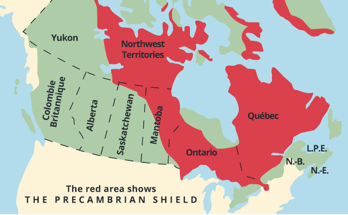 |
| borrowed from https://www.google.ca/search?q=map+of+canadian+shield&safe=strict&rlz=1C1AVSX_ enUS393US394&tbm=isch&imgil=c3gcEk7bynzqzM%253A%253Bi2FdYJFtq5Tt%253Bhttps%25253A %25252F%25252Fss9geography.wikispaces.com%25252FCanadian%2525252BShield&source=iu&pf=m&fir =c3gcEk7bynzqzM%253A%252Ci2FdYJFtq5Tt%252C_&usg=__LrQ9ttsUFo37YNU0YuT48tX7TRY%3 D&biw=1366&bih=676&ved=0ahUKEwitnLay1IfUAhVpxoMKHR_lAA4QyjcINQ&ei=igclWa2vEOmMjw SfyoNw#imgdii=ATNJGQzFt4byaM:&imgrc=c3gcEk7bynzqzM: |

The terrain is drier and is showing sandy and rocky soil.

We crossed another bridge, this one under renovation.

Wood Buffalo National Park is the largest national park in North America. It protects the wood buffalo which is the largest land mammal in North America. The buffalo looks a little different and is 10 - 15% heavier than the plains buffalo. The park protects whooping cranes. The park is also the world's largest dark sky preserve.

This sink hole used to be an underground cave. The roof caved in and we have this. It is 100 metres across.

This lovely little flower was blooming at the top of the crater.

There were a lot of burned out areas at the west side of the park.

There were occasional big rocks strewn here and there. They seemed out of place.

This is the fire observation tower and camp for that region.

Many of the power poles had nesting ravens in them.

There are tiny little pine trees growing here. It is hard to see them.
We came into Hay River which is at the south end of Great Slave Lake. Yellowknife is 200 miles north as the crow flies.
https://www.google.ca/search?q=map+of+Great+slave+Lake&rlz=1C1AVSX_enUS393US394&oq=map+of+Great+slave+Lake&aqs=chrome..69i57j0l2j69i64.6191j0j4&sourceid=chrome&ie=UTF-8
The capital of NWT is Yellowknife, at the top of the map. Hay River is at the bottom of the map. The road goes up and around. There is a bridge in the narrow part to cross over. Until that bridge, traffic drove on an ice road in the winter. In the summer the vehicles were ferried. In the spring and fall no one travelled between Yellowknife and anything south because of the thin ice and ice chunks.

 We drove down to the harbor and ice still covers most of the Lake. Great Slave Lake is the 9th largest lake in the world. When it freezes over roads are made to shorten travel. Do you remember the TV show called Ice road Truckers? Great slave Lake is where it was filmed. Winter was the time that equipment was shipped in to the many mines north of Great Slave Lake.

Oil rail cars are unloaded and stored in these tanks.

Then shipped to Yellowknife.

Hay River is 193 miles north of high Level. It takes a little more than 3 hours to drive. Hay River is in the High Level Branch. We don't know of any members living in Hay River.
We took the side trip to Wood Buffalo NP and all the waterfalls, which made our day longer than the 3 hours.
We stayed in Hay River the 2nd night and started out early. The sunrise that morning was 4:27 am. It had been light since 2:58 am. "We're not in Kansas anymore, Toto."


 This is the bridge we crossed. And a man fishing.


The forest and terrain is very different here. There is very little soil and lots of rocks

From the Junction of Enterprise to the Highway 3 junction going to Yellowknife is 65 miles. We passed 21 vehicles going the other way. Nobody passed us going our way. From the time we got on Highway 3 to Yellowknife was 210 miles. We saw 139 vehicles, 3 cars passed us.

The Yellowknife skyline.
We had a nice trip from Grande Prairie to Yellowknife. We didn't push it. We stopped along the way to view Canada. It is a long way between things. We did things to keep it from getting boring. We would see things in the distance and wonder what kind of animal it was. It usually was a rock, a shrub or mound of dirt. We did see a pair of foxes, several rabbits, some deer and two porcupines. We saw ducks, loons, red wing blackbirds, hawks, ravens, barn swallows, sandpipers and a few geese. There are no signs to play ABC, and no license plates different than the province or territory you are in. It is not surprising that Canadians don't come north very often. They go south. They have family there, plus there are towns and sights along the way. They should give it a try. The roads were in much better shape than Highway 43 going south, except for the last stretch into Yellowknife. We admire the modern pioneers who live in out of the way places. High Level is a big lumber industry. Hay River has shipping, fishing and tourism. Yellowknife has diamond mining, the arts, tourism. They are unique places with special people. We have a lot to explore, and we are going to like it here.
Love, Sister Brown, Mom, Grandma, and Robyn